Please click here for the updated version of this post
This Post covers
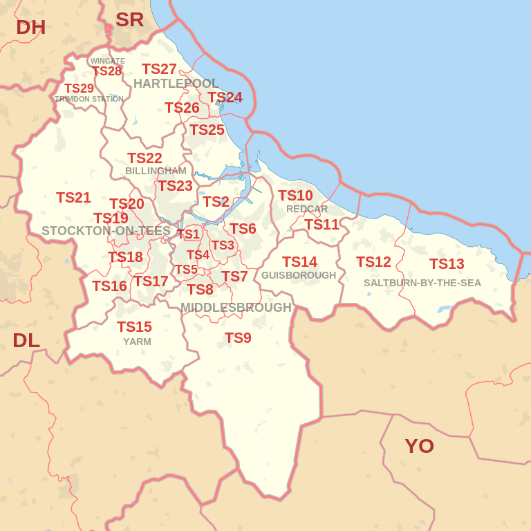
- Coverage Area of Postcode TS10 to TS19
- Total Sales By Postcode TS10 to TS19 in 2016
- Average & Median Sales Price By Postcode TS10 to TS19 in 2016
- Spread of Sales Price By Postcode TS10 to TS19 in 2016
- Total Number of Sales By Postcode TS10 to TS19 in 2016
- Property Posts for Postcode Area TS
- Schools for Postcode Area TS
Coverage Area of Postcode TS10 to TS19
|
|
| Postcode |
Coverage Area |
Local Authority Area |
| TS10 |
Redcar |
Redcar and Cleveland |
| TS11 |
Marske-by-the-Sea, New Marske |
Redcar and Cleveland |
| TS12 |
Saltburn-by-the-Sea, Skelton-in-Cleveland, Brotton |
Redcar and Cleveland |
| TS13 |
Loftus, Skinningrove, Staithes |
Redcar and Cleveland, Scarborough |
| TS14 |
Guisborough |
Redcar and Cleveland |
| TS15 |
Yarm, Kirklevington |
Stockton-on-Tees |
| TS16 |
Eaglescliffe, Egglescliffe, Aislaby |
Stockton-on-Tees |
| TS17 |
Thornaby, Ingleby Barwick, Stainton (part) |
Stockton-on-Tees, Middlesbrough |
| TS18 |
Central, Hartburn, Preston-on-Tees, Grangefield, Oxbridge, Portrack |
Stockton-on-Tees |
| TS19 |
Newtown, Fairfield, Hardwick, Roseworth, Bishopsgarth, Elm Tree Farm |
Stockton-on-Tees |
Total Sales By Postcode in 2016

*M represents Million Pounds
Average & Median Sales Price By Postcode in 2016


*Average and Median Sales Price are in Pounds
Spread of Sales Price By Postcode in 2016

*STDEV is Standard Deviation
For example,
- Say the average detached property price for postcode XYZ is £300 K and ST. DEV. is 30 K.
- It means that most detached properties in postcode XYZ (about 68%) has price within one ST. Dev. i.e. the price range is £270K - £330K.
- All-most all detached property price (95%) in postcode XYZ lie between two ST. Dev. i.e. £240 K - £360 K
Total Number Of Sales By Postcode in 2016

Property Posts for Postcode Area TS
Schools for Postcode Area TS
- TS Postcode Area - TS1, TS2, TS3, TS4, TS5, TS6, TS7, TS8, TS9 School Details
- TS Postcode Area - TS10, TS11, TS12, TS13, TS14, TS15, TS16, TS17, TS18, TS19 School Details
- TS Postcode Area - TS20, TS21, TS22, TS23, TS24, TS25, TS26, TS27, TS28, TS29 School Details
North East England Postcode Area Posts

Reference
NE Postcode Area As Per Wikipedia
a8a05e14-4daa-4255-990d-5ea275373075|0|.0|27604f05-86ad-47ef-9e05-950bb762570c