14. April 2018 23:29
/
VInsights Team
/
/
Comments (0)
Please click here for the updated version of this post
This Post covers
Coverage Area of Postcode WN1 to WN8
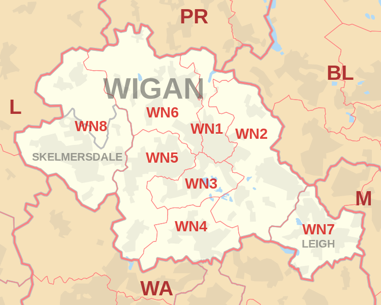 |
| Postcode |
Coverage Area |
Local Authority Area |
| WN1 |
Haigh, Ince, Swinley, Wigan |
Wigan |
| WN2 |
Abram, Aspull, Bamfurlong, Bickershaw, Haigh, Hindley, Hindley Green, Ince, Platt Bridge |
Wigan |
| WN3 |
Goose Green, Ince, Winstanley, Worsley Mesnes, Hawkley Hall |
Wigan |
| WN4 |
Ashton-in-Makerfield, Garswood |
Wigan, St Helens |
| WN5 |
Billinge, Newtown, Higher End, Orrell, Pemberton,
Winstanley, Worsley Hall, Marsh Green. |
Wigan, St Helens |
| WN6 |
Appley Bridge, Shevington, Standish, Standish Lower Ground, Wrightington |
Wigan, West Lancashire |
| WN7 |
Hope Carr, Landside, Leigh, Low Common, Bedford, Westleigh, Pennington, Higher Folds |
Wigan |
| WN8 |
Chapel House, Dalton, Holland Moor, Newburgh, Parbold,
Roby Mill, Skelmersdale, Southway, Upholland |
West Lancashire |

- M represents Million Pounds
- Total value includes Property Type Other apart from Detached, Semi-Detached, Terraced, Flat/Masionette
Schools for Postcode Area WN
Property Posts for Postcode Area WN
4bb0d2b1-07c6-4459-8cd0-60533f936f8d|0|.0|27604f05-86ad-47ef-9e05-950bb762570c
Tags :
14. April 2018 23:04
/
VInsights Team
/
/
Comments (0)
Please click here for the updated version of this post
This Post covers
Coverage Area of Postcode WA10 to WA16
 |
| Postcode |
Coverage Area |
Local Authority Area |
| WA10 |
Eccleston, St. Helens, West Park |
St Helens |
| WA11 |
Crank, Haydock, Moss Bank, Rainford |
St Helens |
| WA12 |
Newton-le-Willows, Earlestown |
St Helens |
| WA13 |
Lymm, Statham, Warburton |
Warrington, Trafford |
| WA14 |
Altrincham, Bowdon, Broadheath, Dunham Town,
Timperley, Dunham Massey, Little Bollington |
Trafford, Cheshire East |
| WA15 |
Altrincham, Ashley, Hale, Hale Barns, Timperley, Ringway |
Trafford, Manchester,
Cheshire East |
| WA16 |
High Legh, Knutsford, Mobberley, Ollerton |
Cheshire East |

- M represents Million Pounds
- Total value includes Property Type Other apart from Detached, Semi-Detached, Terraced, Flat/Masionette
Schools for Postcode Area WA
- WA Postcode Area - WA1, WA2, WA3, WA4, WA5, WA6, WA7, WA8, WA9 School Details
- WA Postcode Area - WA10, WA11, WA12, WA13, WA14, WA15, WA16 School Details
Property Posts for Postcode Area WA
cf9d7a44-a9b0-47da-8c50-8544f4b92e35|0|.0|27604f05-86ad-47ef-9e05-950bb762570c
Tags :
14. April 2018 23:01
/
VInsights Team
/
/
Comments (0)
Please click here for the updated version of this post
This Post covers
Coverage Area of Postcode WA1 to WA9
 |
| Postcode |
Coverage Area |
Local Authority Area |
| WA1 |
Warrington, Town Centre, Woolston, Paddington, Bruche |
Warrington |
| WA2 |
Warrington, Orford, Longford, Dallam, Padgate, Fearnhead |
Warrington |
| WA3 |
Lowton, Golborne, Birchwood, Rixton with Glazebrook, Culcheth |
Wigan, Warrington |
| WA4 |
Warrington, Latchford, Stockton Heath, Appleton,
Grappenhall, Daresbury, Moore, Walton, Preston on the Hill |
Warrington, Halton,
Cheshire West and Chester |
| WA5 |
Warrington, Burtonwood, Westbrook, Penketh, Great Sankey, White Cross |
Warrington |
| WA6 |
Frodsham, Helsby |
Cheshire West and Chester |
| WA7 |
Runcorn |
Halton |
| WA8 |
Widnes, Cronton |
Halton, Knowsley |
| WA9 |
Clock Face, Sutton, Thatto Heath |
St Helens |

- M represents Million Pounds
- Total value includes Property Type Other apart from Detached, Semi-Detached, Terraced, Flat/Masionette
Schools for Postcode Area WA
- WA Postcode Area - WA1, WA2, WA3, WA4, WA5, WA6, WA7, WA8, WA9 School Details
- WA Postcode Area - WA10, WA11, WA12, WA13, WA14, WA15, WA16 School Details
Property Posts for Postcode Area WA
87a26d84-88e6-4b75-b382-27a598eba70b|0|.0|27604f05-86ad-47ef-9e05-950bb762570c
Tags :
14. April 2018 22:41
/
VInsights Team
/
/
Comments (0)
Please click here for the updated version of this post
This Post covers
Coverage Area of Postcode SK10 to SK23
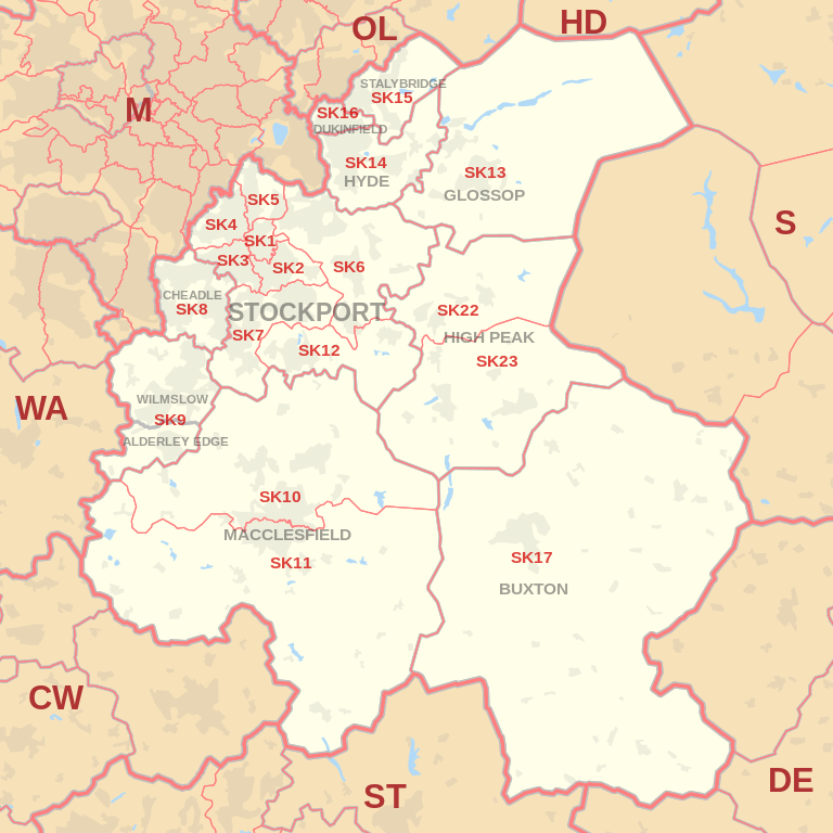 |
| Postcode |
Coverage Area |
Local Authority Area |
| SK10 |
Macclesfield (north), Bollington, Pott Shrigley, Prestbury, Rainow |
Cheshire East |
| SK11 |
Macclesfield (south), Sutton, Rushton Spencer |
Cheshire East, Staffordshire Moorlands |
| SK12 |
Disley, Poynton |
Cheshire East |
| SK13 |
Glossop, Hadfield |
High Peak |
| SK14 |
Hyde, Broadbottom, Gee Cross, Hollingworth, Mottram in Longdendale |
Tameside |
| SK15 |
Stalybridge, Carrbrook, Heyrod, Matley, Millbrook |
Tameside |
| SK16 |
Dukinfield |
Tameside |
| SK17 |
Buxton, Tideswell, Hartington, Longnor, Chelmorton |
High Peak, Derbyshire Dales,
Staffordshire Moorlands |
| SK22 |
Birch Vale, Hayfield, Little Hayfield, New Mills, Rowarth |
High Peak |
| SK23 |
Buxworth, Chapel-en-le-Frith, Chinley, Combs,
Furness Vale, Kettleshulme, Whaley Bridge |
Cheshire East, High Peak |

- M represents Million Pounds
- Total value includes Property Type Other apart from Detached, Semi-Detached, Terraced, Flat/Masionette
Schools for Postcode Area SK
- SK Postcode Area - SK1, SK2, SK3, SK4, SK5, SK6, SK7, SK8, SK9 School Details
- SK Postcode Area - SK10, SK11, SK12, SK13, SK14, SK15, SK16, SK17, SK22, SK23 School Details
Property Posts for Postcode Area SK
655f6e45-4a81-48f3-a820-71fce456bf42|0|.0|27604f05-86ad-47ef-9e05-950bb762570c
Tags :
14. April 2018 21:32
/
VInsights Team
/
/
Comments (0)
Please click here for the updated version of this post
This Post covers
Coverage Area of Postcode SK1 to SK9
|
| Postcode |
Coverage Area |
Local Authority Area |
| SK1 |
Stockport |
Stockport |
| SK2 |
Stockport, Offerton |
Stockport |
| SK3 |
Stockport, Davenport, Edgeley, Adswood, Bridgehall |
Stockport |
| SK4 |
Stockport, Four Heatons, Heaton Moor |
Stockport |
| SK5 |
Stockport, Brinnington, Reddish |
Stockport |
| SK6 |
Bredbury, Romiley, Woodley, Marple, Marple Bridge, High Lane |
Stockport |
| SK7 |
Bramhall, Hazel Grove, Woodford |
Stockport |
| SK8 |
Cheadle, Cheadle Hulme, Gatley, Heald Green |
Stockport |
| SK9 |
Wilmslow, Alderley Edge, Handforth, Styal |
Cheshire East |

- M represents Million Pounds
- Total value includes Property Type Other apart from Detached, Semi-Detached, Terraced, Flat/Masionette
Schools for Postcode Area SK
- SK Postcode Area - SK1, SK2, SK3, SK4, SK5, SK6, SK7, SK8, SK9 School Details
- SK Postcode Area - SK10, SK11, SK12, SK13, SK14, SK15, SK16, SK17, SK22, SK23 School Details
Property Posts for Postcode Area SK
c91638c6-26e3-4ba8-a831-637e671f6485|0|.0|27604f05-86ad-47ef-9e05-950bb762570c
Tags :