14. April 2018 22:41
/
VInsights Team
/
/
Comments (0)
Please click here for the updated version of this post
This Post covers
Coverage Area of Postcode SK10 to SK23
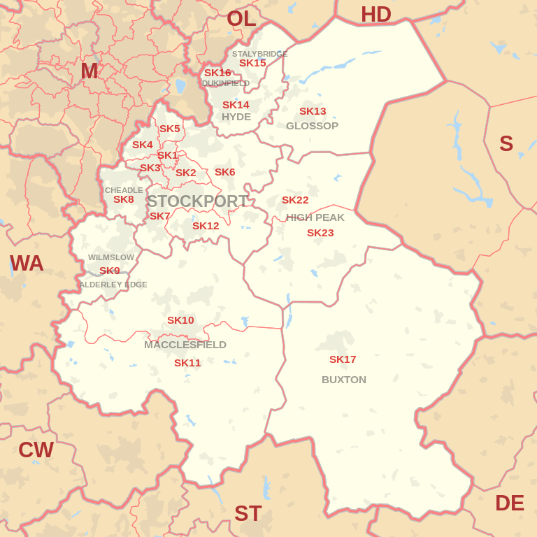 |
| Postcode |
Coverage Area |
Local Authority Area |
| SK10 |
Macclesfield (north), Bollington, Pott Shrigley, Prestbury, Rainow |
Cheshire East |
| SK11 |
Macclesfield (south), Sutton, Rushton Spencer |
Cheshire East, Staffordshire Moorlands |
| SK12 |
Disley, Poynton |
Cheshire East |
| SK13 |
Glossop, Hadfield |
High Peak |
| SK14 |
Hyde, Broadbottom, Gee Cross, Hollingworth, Mottram in Longdendale |
Tameside |
| SK15 |
Stalybridge, Carrbrook, Heyrod, Matley, Millbrook |
Tameside |
| SK16 |
Dukinfield |
Tameside |
| SK17 |
Buxton, Tideswell, Hartington, Longnor, Chelmorton |
High Peak, Derbyshire Dales,
Staffordshire Moorlands |
| SK22 |
Birch Vale, Hayfield, Little Hayfield, New Mills, Rowarth |
High Peak |
| SK23 |
Buxworth, Chapel-en-le-Frith, Chinley, Combs,
Furness Vale, Kettleshulme, Whaley Bridge |
Cheshire East, High Peak |

- M represents Million Pounds
- Total value includes Property Type Other apart from Detached, Semi-Detached, Terraced, Flat/Masionette
Schools for Postcode Area SK
- SK Postcode Area - SK1, SK2, SK3, SK4, SK5, SK6, SK7, SK8, SK9 School Details
- SK Postcode Area - SK10, SK11, SK12, SK13, SK14, SK15, SK16, SK17, SK22, SK23 School Details
Property Posts for Postcode Area SK
655f6e45-4a81-48f3-a820-71fce456bf42|0|.0|27604f05-86ad-47ef-9e05-950bb762570c
Tags :