14. April 2018 23:29
/
VInsights Team
/
/
Comments (0)
Please click here for the updated version of this post
This Post covers
Coverage Area of Postcode WN1 to WN8
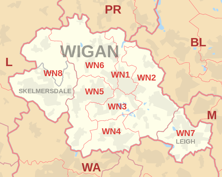 |
| Postcode |
Coverage Area |
Local Authority Area |
| WN1 |
Haigh, Ince, Swinley, Wigan |
Wigan |
| WN2 |
Abram, Aspull, Bamfurlong, Bickershaw, Haigh, Hindley, Hindley Green, Ince, Platt Bridge |
Wigan |
| WN3 |
Goose Green, Ince, Winstanley, Worsley Mesnes, Hawkley Hall |
Wigan |
| WN4 |
Ashton-in-Makerfield, Garswood |
Wigan, St Helens |
| WN5 |
Billinge, Newtown, Higher End, Orrell, Pemberton,
Winstanley, Worsley Hall, Marsh Green. |
Wigan, St Helens |
| WN6 |
Appley Bridge, Shevington, Standish, Standish Lower Ground, Wrightington |
Wigan, West Lancashire |
| WN7 |
Hope Carr, Landside, Leigh, Low Common, Bedford, Westleigh, Pennington, Higher Folds |
Wigan |
| WN8 |
Chapel House, Dalton, Holland Moor, Newburgh, Parbold,
Roby Mill, Skelmersdale, Southway, Upholland |
West Lancashire |

- M represents Million Pounds
- Total value includes Property Type Other apart from Detached, Semi-Detached, Terraced, Flat/Masionette
Schools for Postcode Area WN
Property Posts for Postcode Area WN
4bb0d2b1-07c6-4459-8cd0-60533f936f8d|0|.0|27604f05-86ad-47ef-9e05-950bb762570c
Tags :