Please click here for the updated version of this post
This Post covers
- Coverage Area of Postcode YO15 to YO22
- Total Sales By Postcode YO15 to YO22
- Average & Median Sales Price By Postcode YO15 to YO22
- Spread of Sales Price By Postcode YO15 to YO22
- Total Number of Sales By Postcode YO15 to YO22
- Other Property Posts for Postcode Area YO
- Schools for Postcode Area YO
Coverage Area of Postcode YO15 to YO22
|
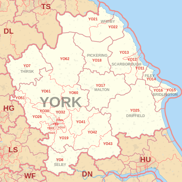
|
| Postcode |
Coverage Area |
Local Authority Area |
| YO15 |
Bridlington, Bempton, Buckton, Carnaby, Flamborough, Fraisthorpe, Sewerby, Wilsthorpe |
East Riding Of Yorkshire |
| YO16 |
Bridlington, Bempton, Bessingby, Boynton, Buckton, Carnaby, Grindale, Sewerby |
East Riding Of Yorkshire |
| YO17 |
Norton |
North Yorkshire County Council |
| YO18 |
Pickering, Thornton-le-Dale |
North Yorkshire County Council |
| YO19 |
Dunnington, Escrick, Wheldrake, Murton, Riccall, Stillingfleet, Warthill |
|
| YO21 |
Whitby, Westerdale |
North Yorkshire County Council |
| YO22 |
Robin Hood's Bay |
North Yorkshire County Council |
Total Sales By Postcode
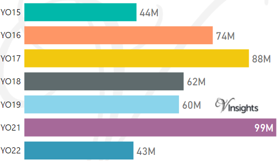
*M represents Million Pounds
Average & Median Sales Price By Postcode
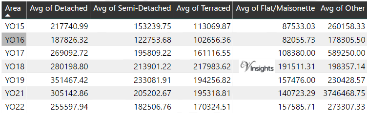
*Average and Median Sales Price are in Pounds
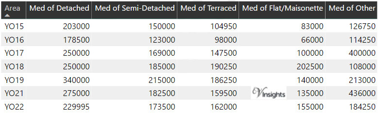
Spread of Sales Price By Postcode
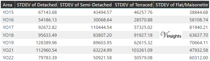
*STDEV is Standard Deviation
For example,
- Say the average detached property price for postcode XYZ is £300 K and ST. DEV. is 30 K.
- It means that most detached properties in postcode XYZ (about 68%) has price within one ST. Dev. i.e. the price range is £270K - £330K.
- All-most all detached property price (95%) in postcode XYZ lie between two ST. Dev. i.e. £240 K - £360 K
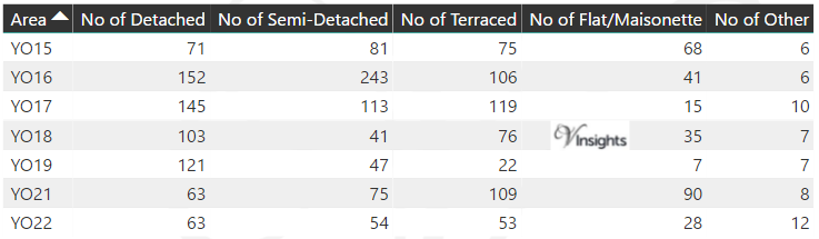
Total Number Of Sales By Postcode
Property Posts for Postcode Area YO
Schools for Postcode Area YO
- YO Postcode Area - YO1, YO7, YO8, Y10, YO11, YO12, YO13, YO14 School Details
- YO Postcode Area - YO15, YO16, YO17, YO18, YO19, YO21, YO22 School Details
- YO Postcode Area - YO23, YO24, YO25, YO26, YO30, YO31, YO32 School Details
- YO Postcode Area - YO41, YO42, YO43, YO51, YO60, YO61, YO62, YO90 School Details
All Yorkshire & Humber Postcode Area Posts

Reference
YO Postcode Area As Per Wikipedia
c2012579-1969-4b33-8040-d2cd374d140a|0|.0|27604f05-86ad-47ef-9e05-950bb762570c