22. April 2018 20:20
/
VInsights Team
/
/
Comments (0)
Please click here for the updated version of this post
This Post covers
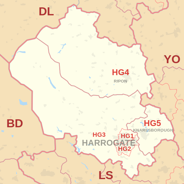
Coverage Area of Postcode HG1 to HG5
|
|
| Postcode |
Coverage Area |
Local Authority Area |
| HG1 |
Central, Bilton, Jennyfields, Duchy, New Park |
Harrogate |
| HG2 |
Oatlands, Woodlands, Hookstone, Rossett,
Pannal Ash, Harlow Hill, Hornbeam Park |
Harrogate |
| HG3 |
Pannal, Killinghall, Spofforth, Bishop Monkton,
Glasshouses, Follifoot, Pateley Bridge |
Harrogate |
| HG4 |
Ripon, North Stainley, High Grantley, Masham,
West Tanfield, Thornton Watlass, Thornton Steward |
Harrogate, Hambleton,
Richmondshire |
| HG5 |
Scotton, Knaresborough |
Harrogate |
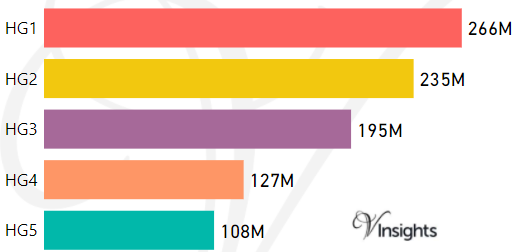
- M represents Million Pounds
- Total value includes Property Type Other apart from Detached, Semi-Detached, Terraced, Flat/Masionette
Schools for Postcode Area HG
Property Posts for Postcode Area HG
bcd3f292-da37-4612-a1a6-f186a2435158|0|.0|27604f05-86ad-47ef-9e05-950bb762570c
Tags :