Please click here for the updated version of this post
This Post covers
- Coverage Area of Postcode DN1 to DN9
- Total Sales By Postcode DN1 to DN9
- Average & Median Sales Price By Postcode DN1 to DN9
- Spread of Sales Price By Postcode DN1 to DN9
- Total Number of Sales By Postcode DN1 to DN9
- Other Property Posts for Postcode Area DN
- Schools for Postcode Area DN
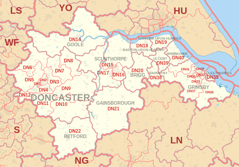
Coverage Area of Postcode DN1 to DN9
|
|
| Postcode |
Coverage Area |
Local Authority Area |
| DN1 |
Doncaster Town Centre |
Doncaster |
| DN2 |
Intake, Wheatley, Wheatley Hills |
Doncaster |
| DN3 |
Armthorpe, Barnby Dun, Branton, Edenthorpe, Kirk Sandall |
Doncaster |
| DN4 |
Balby, Belle Vue, Bessacarr, Cantley, Hexthorpe, Warmsworth |
Doncaster |
| DN5 |
Arksey, Barnburgh, Bentley, Cadeby, Cusworth, Harlington,
High Melton, Scawsby, Scawthorpe, Sprotborough, Sunnyfields, Toll Bar |
Barnsley, Doncaster, Rotherham |
| DN6 |
Adwick-le-Street, Askern, Campsall, Carcroft,
Moss, Norton, Sutton, Walden Stubbs, Woodlands |
Doncaster, Selby |
| DN7 |
Dunsville, Dunscroft, Fishlake, Hatfield,
Hatfield Woodhouse, Lindholme, Stainforth |
Doncaster |
| DN8 |
Moorends, Sandtoft, Thorne |
Doncaster |
| DN9 |
Epworth, Finningley, Haxey, Auckley,
Owston Ferry, Belton, Westwoodside |
Doncaster, North Lincolnshire |
Total Sales By Postcode
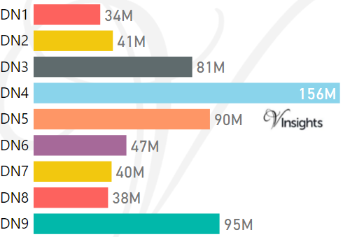
*M represents Million Pounds
Average & Median Sales Price By Postcode 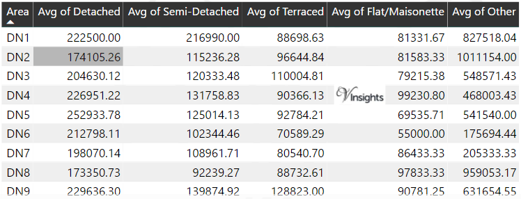
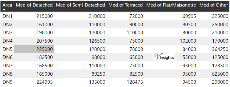
*Average and Median Sales Price are in Pounds
Spread of Sales Price By Postcode
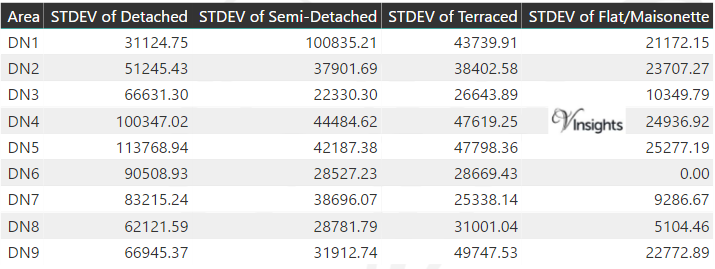
*STDEV is Standard Deviation
For example,
- Say the average detached property price for postcode XYZ is £300 K and ST. DEV. is 30 K.
- It means that most detached properties in postcode XYZ (about 68%) has price within one ST. Dev. i.e. the price range is £270K - £330K.
- All-most all detached property price (95%) in postcode XYZ lie between two ST. Dev. i.e. £240 K - £360 K
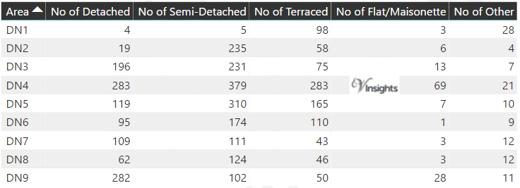
Total Number Of Sales By Postcode
Property Posts for Postcode Area DN
Schools for Postcode Area DN
- DN Postcode Area - DN1, DN2, DN3, DN4, DN5, DN6, DN7, DN8, DN9 School Details
- DN Postcode Area - DN10, DN11, DN12, DN14, DN15, DN16, DN17, DN18, DN19 School Details
- DN Postcode Area - DN20, DN21, DN22, DN31, DN32, DN33, DN34, DN35 School Details
- DN Postcode Area - DN36, DN37, DN38, DN39, DN40, DN41 School Details
All Yorkshire & Humber Postcode Area Posts

Reference
DN Postcode Area As Per Wikipedia
42a7c5fc-a65e-4e21-b899-e51911fb595e|0|.0|27604f05-86ad-47ef-9e05-950bb762570c