This Post covers
- Coverage Area of Postcode CO1 to CO9
- School Details for Postcode Area CO1 to CO9
- Other Schools for Postcode Area CO
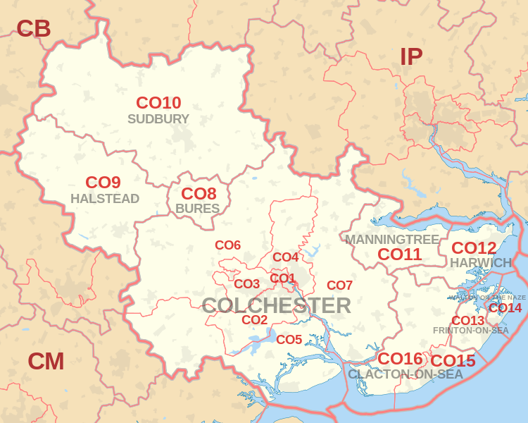
Coverage Area of Postcode CO1 to CO9
 |
| Postcode |
Coverage Area |
Local Authority Area |
| CO1 |
Colchester |
Colchester |
| CO2 |
Colchester, Old Heath, Berechurch, Layer de la Haye |
Colchester |
| CO3 |
Colchester, Lexden, Stanway |
Colchester |
| CO4 |
Colchester, Myland, Boxted |
Colchester |
| CO5 |
Tiptree, Kelvedon, West Mersea, Peldon, Rowhedge |
Colchester, Braintree, Maldon |
| CO6 |
Coggeshall, Earls Colne, Marks Tey, Great Tey,
Chappel, Wakes Colne, Copford, West Bergholt,
Great Horkesley, Wormingford, Nayland, Stoke-by-Nayland, Polstead |
Colchester, Braintree, Babergh |
| CO7 |
Brightlingsea, Wivenhoe, Great Bentley |
Colchester, Tendring |
| CO8 |
Bures, Alphamstone |
Colchester, Braintree, Babergh |
| CO9 |
Halstead |
Braintree |
where *F.S. = Faith School, *PERF = Performance, *D.F.E.=Department For Education
Schools in Postcode CO1
Schools in Postcode CO2
Schools in Postcode CO3
Schools in Postcode CO4
Schools in Postcode CO5
Schools in Postcode CO6
Schools in Postcode CO7
Schools in Postcode CO8
Schools in Postcode CO9
where *F.S. = Faith School, *PERF = Performance, *D.F.E.=Department For Education
Other Schools for Postcode Area CO
All CO Postcodes Yearly & Trend Analysis Posts

49f0c4d7-7d78-41e5-a8ee-81f5465389df|0|.0|27604f05-86ad-47ef-9e05-950bb762570c