
This Post covers
- Coverage Area of Postcode WN1 to WN9
- School Details for Postcode Area WN1 to WN9
- Property Market Posts for Postcode Area WN
Coverage Area of Postcode WN1 to WN8
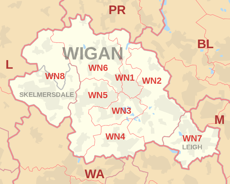 |
| Postcode |
Coverage Area |
Local Authority Area |
| WN1 |
Haigh, Ince, Swinley, Wigan |
Wigan |
| WN2 |
Abram, Aspull, Bamfurlong, Bickershaw, Haigh, Hindley, Hindley Green, Ince, Platt Bridge |
Wigan |
| WN3 |
Goose Green, Ince, Winstanley, Worsley Mesnes, Hawkley Hall |
Wigan |
| WN4 |
Ashton-in-Makerfield, Garswood |
Wigan, St Helens |
| WN5 |
Billinge, Newtown, Higher End, Orrell, Pemberton,
Winstanley, Worsley Hall, Marsh Green. |
Wigan, St Helens |
| WN6 |
Appley Bridge, Shevington, Standish, Standish Lower Ground, Wrightington |
Wigan, West Lancashire |
| WN7 |
Hope Carr, Landside, Leigh, Low Common, Bedford, Westleigh, Pennington, Higher Folds |
Wigan |
| WN8 |
Chapel House, Dalton, Holland Moor, Newburgh, Parbold,
Roby Mill, Skelmersdale, Southway, Upholland |
West Lancashire |
where *F.S. = Faith School, *PERF = Performance, *D.F.E.=Department For Education
Schools in Postcode WN1
Schools in Postcode WN2
Schools in Postcode WN3
Schools in Postcode WN4
Schools in Postcode WN5
Schools in Postcode WN6
Schools in Postcode WN7
Schools in Postcode WN8
where *F.S. = Faith School, *PERF = Performance, *D.F.E.=Department For Education
Property Market Posts for Postcode Area WN
All North West England Schools

9816f42a-2c3c-4f5b-9d34-ceb0e4bc5491|0|.0|27604f05-86ad-47ef-9e05-950bb762570c