 This Post covers
- Coverage Area of Postcode SN1 to SN9
- School Details for Postcode Area SN1 to SN9
- Other Schools for Postcode Area SN
Coverage Area of Postcode SN1 to SN9
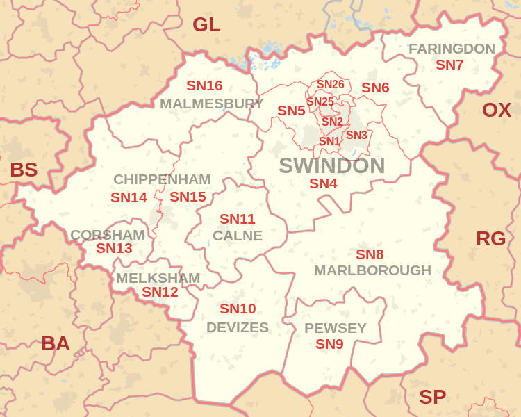 |
| Postcode |
Coverage Area |
Local Authority Area |
| SN1 |
Swindon Centre, south of the railway line |
Swindon |
| SN2 |
Swindon, north & Upper Stratton |
Swindon |
| SN3 |
Swindon, east & Stratton St Margaret, South Marston |
Swindon |
| SN4 |
Chiseldon, Royal Wootton Bassett, Wroughton |
Swindon, Wiltshire |
| SN5 |
West Swindon, Purton, Grange Park |
Swindon |
| SN6 |
Highworth, Cricklade, Shrivenham, Watchfield,
Ashton Keynes, Ashbury, Bishopstone, Castle Eaton, Hannington, Idstone, Marston Meysey, Leigh |
Swindon, Wiltshire, Vale of White Horse |
| SN7 |
Faringdon, Stanford in the Vale, Uffington, Longcot, Fernham, Buckland, Great Coxwell, Little Coxwell, Littleworth, Shellingford, Buscot |
Vale of White Horse |
| SN8 |
Marlborough, Ramsbury, Mildenhall, Aldbourne,
Axford, Burbage, Baydon, Great Bedwyn |
Wiltshire |
| SN9 |
Pewsey, Upavon, Enford |
Wiltshire |
where *F.S. = Faith School, *PERF = Performance, *D.F.E.=Department For Education
Schools in Postcode SN1
Schools in Postcode SN2
Schools in Postcode SN3
Schools in Postcode SN4
Schools in Postcode SN5
Schools in Postcode SN6
Schools in Postcode SN7
Schools in Postcode SN8
Schools in Postcode SN9
where *F.S. = Faith School, *PERF = Performance, *D.F.E.=Department For Education
Other Schools for Postcode Area SN
All SN Postcodes Yearly & Trend Analysis Posts

33e4e03a-68f1-4cc8-b2c8-67ef4745b94f|0|.0|27604f05-86ad-47ef-9e05-950bb762570c