
This Post covers
- Coverage Area of Postcode DA1 to DA9
- School Details for Postcode Area DA1 to DA9
- Other Schools for Postcode Area DA
- Multi Year Property Trend Analysis By Postcode DA1 to DA9
- Posts for Postcode Area DA
Coverage Area of Postcode DA1 to DA9
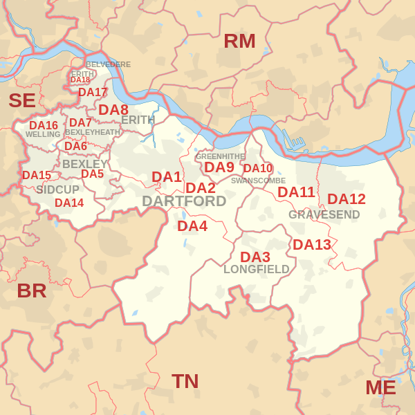 |
| Postcode |
Coverage Area |
Local Authority Area |
| DA1 |
Dartford, Crayford, Barnes Cray |
Bexley, Dartford |
| DA2 |
Dartford (east), Stone, Wilmington, Bean, Hawley, Darenth, part of Joyden's Wood |
Dartford, Sevenoaks |
| DA3 |
Longfield, Hartley, New Ash Green, New Barn, Fawkham |
Dartford, Gravesham, Sevenoaks |
| DA4 |
Farningham, Eynsford, South Darenth, Sutton-at-Hone, Horton Kirby |
Dartford, Sevenoaks |
| DA5 |
Bexley, parts of Albany Park and Joyden's Wood |
Bexley, Dartford |
| DA6 |
Bexleyheath, Upton |
Bexley |
| DA7 |
Bexleyheath (north), Barnehurst |
Bexley |
| DA8 |
Erith, Northumberland Heath, Slade Green |
Bexley |
| DA9 |
Greenhithe, Stone |
Dartford |
where *F.S. = Faith School, *PERF = Performance, *D.F.E.=Department For Education
Schools in Postcode DA1
Schools in Postcode DA2
Schools in Postcode DA3
Schools in Postcode DA4
Schools in Postcode DA5
Schools in Postcode DA6
Schools in Postcode DA7
Schools in Postcode DA8
Schools in Postcode DA9
| School |
Postcode |
Phase |
Gender |
*F.S. |
Ofsted |
*PERF |
*D.F.E. |
Area |
| Stone St Mary's CofE Primary School |
DA9 9EF |
Primary |
Mixed |
Y |
Rating |
Details |
Data |
Kent |
| Knockhall Academy |
DA9 9RF |
Primary |
Mixed |
N |
Rating |
Details |
Data |
Kent |
where *F.S. = Faith School, *PERF = Performance, *D.F.E.=Department For Education
Other Schools for Postcode Area DA
Multi Year Property Trend Analysis By Postcode
Posts for Postcode Area DA
All DA Postcodes Yearly & Trend Analysis Posts

d15cfa58-dc18-4b78-a909-464b4ef2fd04|0|.0|27604f05-86ad-47ef-9e05-950bb762570c