Please click here for the updated version of this post
This Post covers
- Coverage Area of Postcode LL30 to LL39
- Total Sales By Postcode LL30 to LL39
- Average & Median Sales Price By Postcode LL30 to LL39
- Spread of Sales Price By Postcode LL30 to LL39
- Total Number of Sales By Postcode LL30 to LL39
- Posts for Postcode Area LL
Coverage Area of Postcode LL30 to LL39
|
|
| Postcode |
Coverage Area |
Local Authority Area |
| LL30 |
Llanrhos, Llandudno, Penrhyn Bay |
Conwy |
| LL31 |
Glanwydden, Llangwstenin, Llandudno Junction,Deganwy |
Conwy |
| LL32 |
Conwy, Dolgarrog, Groesffordd, Henryd, Rowen, Tal-y-Bont, Tyn-y-Groes |
Conwy |
| LL33 |
Abergwyngregyn, Llanfairfechan |
Conwy, Gwynedd |
| LL34 |
Penmaenmawr, Dwygyfylchi |
Conwy |
| LL35 |
Aberdovey |
Gwynedd |
| LL36 |
Tywyn, Abergynolwyn, Bryncrug, Llanegryn, Rhoslefain |
Gwynedd |
| LL37 |
Llwyngwril |
Gwynedd |
| LL38 |
Fairbourne, Friog |
Gwynedd |
| LL39 |
Arthog |
Gwynedd |
Total Sales By Postcode

*M represents Million Pounds
Average & Median Sales Price By Postcode


*Average and Median Sales Price are in Pounds
Spread of Sales Price By Postcode

*STDEV is Standard Deviation
For example,
- Say the average detached property price for postcode XYZ is £300 K and ST. DEV. is 30 K.
- It means that most detached properties in postcode XYZ (about 68%) has price within one ST. Dev. i.e. the price range is £270K - £330K.
- All-most all detached property price (95%) in postcode XYZ lie between two ST. Dev. i.e. £240 K - £360 K
Total Number Of Sales By Postcode

Posts for Postcode Area LL
All Wales Postcode Area Posts

Reference
LL Postcode Area As Per Wikipedia
ae0bfe6c-c4bb-4169-a9e1-0057f487bf29|0|.0|27604f05-86ad-47ef-9e05-950bb762570c
Please click here for the updated version of this post
This Post covers
- Coverage Area of Postcode LL20 to LL29
- Total Sales By Postcode LL20 to LL29
- Average & Median Sales Price By Postcode LL20 to LL29
- Spread of Sales Price By Postcode LL20 to LL29
- Total Number of Sales By Postcode LL20 to LL29
- Posts for Postcode Area LL
Coverage Area of Postcode LL20 to LL29
|
|
| Postcode |
Coverage Area |
Local Authority Area |
| LL20 |
Froncysyllte, Garth, Glyn Ceiriog, Llanarmon Dyffryn Ceiriog, Llwynmawr, Pandy, Pontfadog, Rhewl, Tregeiriog, Trevor, Llangollen, Eglwyseg, Llantysilio |
Denbighshire, Wrexham |
| LL21 |
Corwen, Cynwyd, Glanrafon, Glasfryn, Llandrillo, Llangwm, Maerdy, Ty Nant, Betws Gwerfil Goch, Bryneglwys, Carrog, Cerrigydrudion, Clawdd Poncen, Derwen, Glyndyfrdwy, Gwyddelwern, Llanfihangel Glyn Myfyr, Llidiart-y-Parc, Melin-y-Wig |
Conwy,Denbighshire, Gwynedd |
| LL22 |
Abergele, Towyn, Betws Yn Rhos, Gwytherin, Llanddulas, Llanfairtalhaiarn, Llangernyw, Moelfre, Pandy Tudur, Rhyd-y-Foel, Glascoed, St. George |
Denbighshire, Conwy |
| LL23 |
Bala, Llandderfel, Llanfor, Llanuwchllyn, Sarnau |
Gwynedd |
| LL24 |
Betws-y-Coed, Capel Curig, Cwm Penmachno, Penmachno, Pentre Du, Pentrefoelas, Ysbyty Ifan |
Conwy |
| LL25 |
Dolwyddelan |
Conwy |
| LL26 |
Llanrwst, Capel Garmon, Llanddoged, Melin-y-Coed, Maenan |
Conwy |
| LL27 |
Trefriw |
Conwy |
| LL28 |
Colwyn Bay, Rhos-on-Sea, Eglwysbach, Glan Conwy, Mochdre, Tal-y-Cafn |
Conwy |
| LL29 |
Colwyn Bay, Llanelian, Llysfaen, Old Colwyn |
Conwy |
Total Sales By Postcode

*M represents Million Pounds
Average & Median Sales Price By Postcode


*Average and Median Sales Price are in Pounds
Spread of Sales Price By Postcode

*STDEV is Standard Deviation
For example,
- Say the average detached property price for postcode XYZ is £300 K and ST. DEV. is 30 K.
- It means that most detached properties in postcode XYZ (about 68%) has price within one ST. Dev. i.e. the price range is £270K - £330K.
- All-most all detached property price (95%) in postcode XYZ lie between two ST. Dev. i.e. £240 K - £360 K
Total Number Of Sales By Postcode

Posts for Postcode Area LL
All Wales Postcode Area Posts
Reference
LL Postcode Area As Per Wikipedia
85350586-97e0-43ea-8154-bcd105c45f13|0|.0|27604f05-86ad-47ef-9e05-950bb762570c
Please click here for the updated version of this post
This Post covers
- Coverage Area of Postcode LL11 to LL19
- Total Sales By Postcode LL11 to LL19
- Average & Median Sales Price By Postcode LL11 to LL19
- Spread of Sales Price By Postcode LL11 to LL19
- Total Number of Sales By Postcode LL11 to LL19
- Posts for Postcode Area LL
Coverage Area of Postcode LL11 to LL19
|
|
| Postcode |
Coverage Area |
Local Authority Area |
| LL11 |
Wrexham, Coedpoeth, Llandegla, Minera, Bradley, Gwersyllt, Rhosrobin, Stansty, Brymbo, Bwlchgwyn, Cymau, Ffrith, Llanfynydd, Gwynfryn, Tanyfron, Brynteg |
Denbighshire, Flintshire, Wrexham |
| LL12 |
Wrexham, Caergwrle, Cefn-y-Bedd, Cymau, Gresford, Hope, Llay, Marford, Rossett |
Flintshire, Wrexham |
| LL13 |
Wrexham, Abenbury, Bowling Bank, Holt, Llan-y-Pwll, Pentre Maelor, Ridley Wood, Bangor-on-Dee, Gyfelia, Marchwiel, Overton, Penley, Worthenbury, Johnstown |
Wrexham |
| LL14 |
Wrexham, Rhosllanerchrugog, Cefn Mawr, Ponciau, Rhostyllen, Chirk, Ruabon |
Shropshire, Wrexham |
| LL15 |
Ruthin, Bontuchel, Clawddnewydd, Clocaenog, Cyffylliog, Gellifor, Graigfechan, Llanbedr Dyffryn Clwyd, Llanelidan, Llanfair Dyffryn Clwyd, Pwllglas, Rhewl |
Denbighshire |
| LL16 |
Denbigh, Bodfari, Llandyrnog, Llanrhaeadr, Bylchau, Groes, Henllan, Llannefydd, Llansannan, Nantglyn, The Green, Trefnant |
Conwy, Denbighshire |
| LL17 |
St. Asaph, Allt Goch, Rhuallt, Tremeirchion, Waen |
Conwy, Denbighshire |
| LL18 |
Rhyl, Bodelwyddan, Cwm Dyserth, Kinmel Bay, Dyserth, Gwaenysgor, Rhuddlan, Trelawnyd |
Conwy,Denbighshire, Flintshire |
| LL19 |
Prestatyn, Gronant |
Denbighshire, Flintshire |
Total Sales By Postcode

*M represents Million Pounds
Average & Median Sales Price By Postcode


*Average and Median Sales Price are in Pounds
Spread of Sales Price By Postcode

*STDEV is Standard Deviation
For example,
- Say the average detached property price for postcode XYZ is £300 K and ST. DEV. is 30 K.
- It means that most detached properties in postcode XYZ (about 68%) has price within one ST. Dev. i.e. the price range is £270K - £330K.
- All-most all detached property price (95%) in postcode XYZ lie between two ST. Dev. i.e. £240 K - £360 K
Total Number Of Sales By Postcode

Posts for Postcode Area LL
All Wales Postcode Area Posts
Reference
LL Postcode Area As Per Wikipedia
3df685e1-3b29-497d-8587-0cfb86db0404|0|.0|27604f05-86ad-47ef-9e05-950bb762570c
Please click here for the updated version of this post
This Post covers
- Coverage Area of Postcode LD1 to LD8
- Total Sales By Postcode LD1 to LD8
- Average & Median Sales Price By Postcode LD1 to LD8
- Spread of Sales Price By Postcode LD1 to LD8
- Total Number of Sales By Postcode LD1 to LD8
- Property Posts for Postcode Area LD
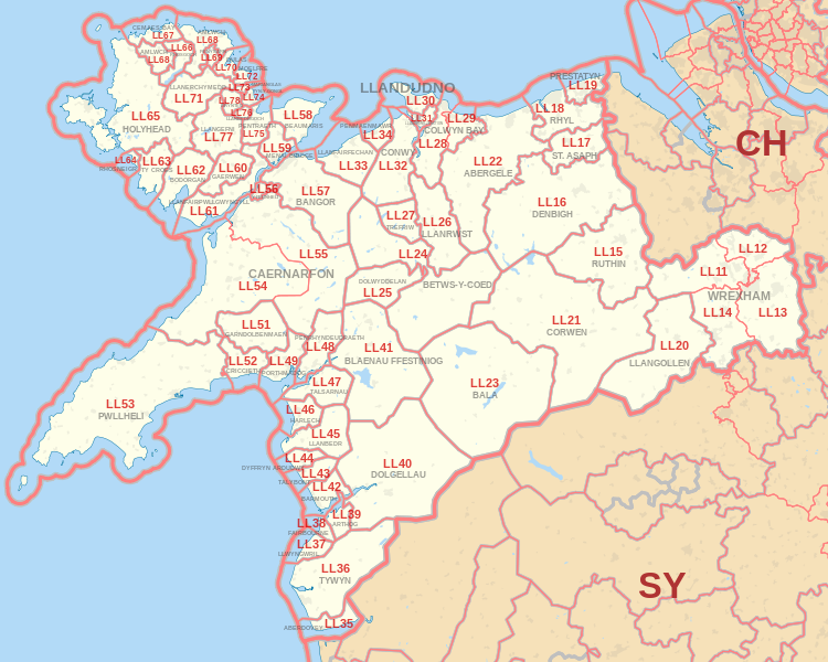
Coverage Area of Postcode LD1 to LD8
|
|
| Postcode |
Coverage Area |
Local Authority Area |
| LD1 |
Llandrindod Wells, Crossgates, Newbridge-on-Wye |
Powys |
| LD2 |
Builth Wells, Llanafan Fawr, Erwood |
Powys |
| LD3 |
Brecon, Talgarth |
Powys |
| LD4 |
Llangammarch Wells, Garth, Cefn Gorwydd |
Powys |
| LD5 |
Llanwrtyd Wells, Beulah, Abergwesyn |
Powys |
| LD6 |
Rhayader, St Harmon, Pant-Y-Dwr |
Powys |
| LD7 |
Knighton, Knucklas, Llangunllo, Llanfair Waterdine |
Powys, Shropshire |
| LD8 |
Presteigne, New Radnor, Norton, Stapleton |
Powys, Herefordshire |
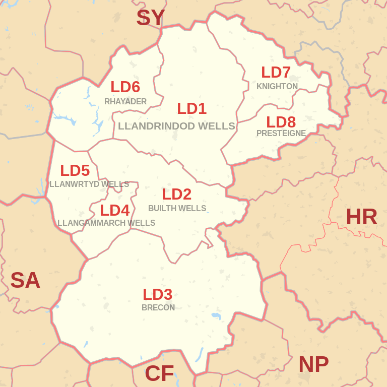
Total Sales By Postcode
*M represents Million Pounds
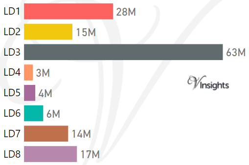
Average & Median Sales Price By Postcode
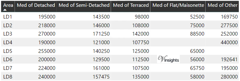
*Average and Median Sales Price are in Pounds
Spread of Sales Price By Postcode
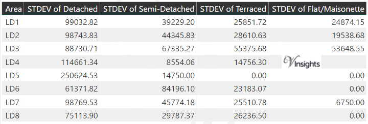
*STDEV is Standard Deviation
For example,
- Say the average detached property price for postcode XYZ is £300 K and ST. DEV. is 30 K.
- It means that most detached properties in postcode XYZ (about 68%) has price within one ST. Dev. i.e. the price range is £270K - £330K.
- All-most all detached property price (95%) in postcode XYZ lie between two ST. Dev. i.e. £240 K - £360 K
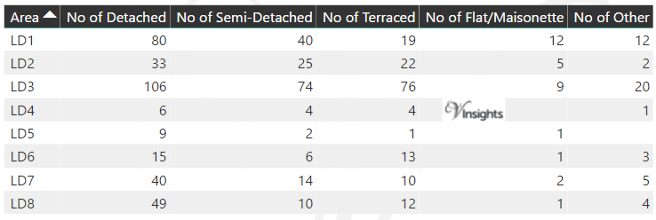
Total Number Of Sales By Postcode
Property Posts for Postcode Area LD
All Wales Postcode Area Posts
Reference
LD Postcode Area As Per Wikipedia
5f33923e-fa82-4e33-9de4-a304e6ad4edd|0|.0|27604f05-86ad-47ef-9e05-950bb762570c
Please click here for the updated version of this post
This Post covers
- Coverage Area of Postcode CF61 to CF83
- Total Sales By Postcode CF61 to CF83
- Average & Median Sales Price By Postcode CF61 to CF83
- Spread of Sales Price By Postcode CF61 to CF83
- Total Number of Sales By Postcode CF61 to CF83
- Posts for Postcode Area CF
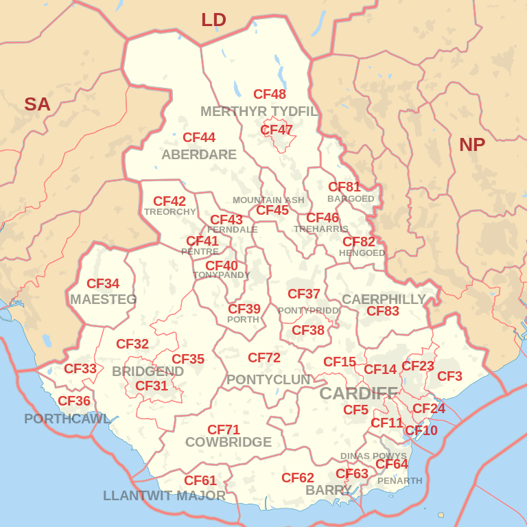
Coverage Area of Postcode CF61 to CF83
|
|
| Postcode |
Coverage Area |
Local Authority Area |
| CF61 |
LLANTWIT MAJOR TOWN, Llan-maes |
Vale Of Glamorgan |
| CF62 |
BARRY TOWN (part of), Rhoose, St Athan, Llancarfan, Barry Island |
Vale Of Glamorgan |
| CF63 |
BARRY TOWN (part of), Cadoxton, Barry Docksd |
Vale Of Glamorgan |
| CF64 |
PENARTH TOWN, Dinas Powys, Sully, Llandough |
Vale Of Glamorgan |
| CF71 |
COWBRIDGE TOWN, St Brides Major, Welsh St Donats, Pendoylan, Llandow, Colwinston, Llanblethian, Penllyn, Llanfair |
Vale Of Glamorgan |
| CF72 |
Taff-Ely Area:PONTYCLUN, LLANTRISANT TOWN, LLANHARAN, Talbot Green, Brynsadler, Miskin, Brynna, LLANHARRY |
Rhondda Cynon Taff |
| CF81 |
BARGOED TOWN, Aberbargoed, Darran Valley, Gilfach, Pontlottyn |
Caerphilly |
| CF82 |
HENGOED, Cefn Hengoed, YSTAD MYNACH TOWN, Gelligaer, Maesycwmmer |
Caerphilly |
| CF83 |
Caerphilly TOWN, Abertridwr, Senghenydd, Bedwas, Trethomas, Machen, Llanbradach, Pwllypant, Penyrheol, Energlyn, Trecenydd, Rudry |
Caerphilly |
Total Sales By Postcode

*M represents Million Pounds
Average & Median Sales Price By Postcode


*Average and Median Sales Price are in Pounds
Spread of Sales Price By Postcode

*STDEV is Standard Deviation
For example,
- Say the average detached property price for postcode XYZ is £300 K and ST. DEV. is 30 K.
- It means that most detached properties in postcode XYZ (about 68%) has price within one ST. Dev. i.e. the price range is £270K - £330K.
- All-most all detached property price (95%) in postcode XYZ lie between two ST. Dev. i.e. £240 K - £360 K
Total Number Of Sales By Postcode

Posts for Postcode Area CF
All Wales Postcode Area Posts
Reference
CF Postcode Area As Per Wikipedia
f5af93e6-ca57-4133-b75d-5f01049f83ef|0|.0|27604f05-86ad-47ef-9e05-950bb762570c